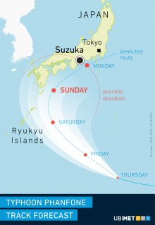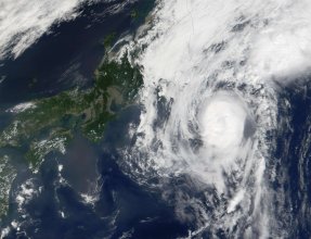
(Reuters) - A powerful typhoon was on course to hit the Tokyo area on Monday, after barreling into southwestern Japan with heavy rain and wind that caused flights to be canceled and knocked out power.
Typhoon Phanfone, which was downgraded from an earlier status of a super typhoon, is moving northeast at 25 kph (16 mph), after lashing parts of the Kyushu and Okinawa islands, the Japan Meteorological Agency said on Sunday.
About 30 cm (12 inches) of rain and heavy wind are forecast for eastern Japan, including the Tokyo metropolitan area.
"My school has already decided not to have classes tomorrow," said Tomoko Kakinuma, a 20-year old college student in Tokyo.
Toyota Motor Corp plans to halt production on Monday morning at 12 plants in Japan due to the storm, a company spokesman said.
On Sunday, several airlines, including All Nippon Airways and Japan Airlines Co, canceled over 150 flights to several southern Japanese cities, broadcaster NHK said.
Kyushu Electric Power Co said about 18,500 households were without power late Sunday afternoon.
Nansei Sekiyu, a Japanese refiner wholly owned by Brazil's Petrobras, has suspended marine operations at its 100,000 barrels-per-day refinery in Okinawa due to the typhoon, but other operations are unaffected, a company spokesman said.
The approaching storm also forced the suspension of search efforts on Mount Ontake in central Japan, where 12 people remain missing following a volcanic eruption that killed at least 51, Kyodo news agency said.
Heavy rain delayed the Japanese Formula One Grand Prix on Sunday, which eventually saw two starts behind the safety car and ended before the full distance due to a crash. Britain's Lewis Hamilton won the race.
Source:
http://www.reuters.com/article/2014/10/05/us-japan-typhoon-idUSKCN0HU03I20141005

The Japan Meteorological Agency, the official regional center for tropical cyclone forecasts in the western North Pacific, indicated 10-minute sustained winds as high as 110 mph within Phanfone Saturday, but has lowered its estimates slightly as well. JMA's 10-minute wind speeds are usually lower than the 1-minute wind standard used by the U.S.
As of Sunday morning local time, the strongest winds are being felt on the small Amami Islands, which are a part of Kagoshima Prefecture and lie north of Okinawa. The island of Kikaijima reported a peak gust of 42.2 meters per second (94.4 mph) at 5:45 a.m. Japanese time Sunday. (Japanese Standard Time, or JST, is 13 hours ahead of Eastern Daylight Time in the U.S.)
On Saturday, high winds were felt in the Daito Islands, which are part of Okinawa Prefecture. A wind gust of 101 mph was reported on Kitadaito (North Daito Island) before the wind observations were knocked offline. The other two observation sites on the islands, Minamidaito and Kyuto, gusted over 90 mph. Sustained winds maxed out at 57 to 64 mph at all three locations, safely below typhoon force, but the center of Phanfone was 120 kilometers (75 miles) away at its closest approach according to JMA bulletins.
Although Phanfone is moving into an area of increasing vertical wind shear (changes in wind speed and direction with height) as well as cooler ocean waters, the storm will be slow to weaken and will still be a very intense system as it approaches the larger islands of Japan.


